|
|
| Línea 77: |
Línea 77: |
| | [[File:Vernal.holley.name.list.jpg|400 px]] | | [[File:Vernal.holley.name.list.jpg|400 px]] |
| | | | |
| − | *{{Answer}}Not only are the ''names'' claimed to be similar to those in the Book of Mormon, but also that the ''locations of those names'' are similar. In addition, since some of these names could have easily been taken from the Bible instead of the surrounding region, one must assume that their inclusion on the map also implies that their geographical locations relative to one another are important. | + | *{{respuesta}}Not only are the ''names'' claimed to be similar to those in the Book of Mormon, but also that the ''locations of those names'' are similar. In addition, since some of these names could have easily been taken from the Bible instead of the surrounding region, one must assume that their inclusion on the map also implies that their geographical locations relative to one another are important. |
| − | *{{Incorrect}} Looking at the geography, it is clear from Holley's map that a number of locations have been selected to make the names match the existing geography. Some examples: | + | *{{incorrecto}} Looking at the geography, it is clear from Holley's map that a number of locations have been selected to make the names match the existing geography. Some examples: |
| | **The map places Jacobugath, site of "King Jacob's" dissenters far in the land southward, when the Book of Mormon has it far in the land northward (3 Nephi 7:9-12; see also 3 Nephi 9:9). | | **The map places Jacobugath, site of "King Jacob's" dissenters far in the land southward, when the Book of Mormon has it far in the land northward (3 Nephi 7:9-12; see also 3 Nephi 9:9). |
| | **The map places the land of first inheritance [land of Lehi-Nephi] is on the eastern coast of the United States, while the Book of Mormon is clear that Lehi and his group landed on the western coast. | | **The map places the land of first inheritance [land of Lehi-Nephi] is on the eastern coast of the United States, while the Book of Mormon is clear that Lehi and his group landed on the western coast. |
| | **The City of Morianton should be by the eastern seashore, near the city of Lehi (Alma 50:25). | | **The City of Morianton should be by the eastern seashore, near the city of Lehi (Alma 50:25). |
| | **"Ramah" is the Jaredite name for the Hill Cumorah (Ether 15:11). The Hill Cumorah is not in Canada. | | **"Ramah" is the Jaredite name for the Hill Cumorah (Ether 15:11). The Hill Cumorah is not in Canada. |
| − | {{SummaryItem | + | {{sumario |
| − | |link=Book of Mormon/Plagiarism accusations/Place names from North America/Holley map | + | |link=El Libro de Mormón/Acusaciones de plagio/Coloque los nombres de América del Norte/El mapa de Vernal Holley |
| − | |subject=North American place names - the Vernal Holley map | + | |sujeto=Nombres de lugares en América del Norte - El mapa de Vernal Holley |
| − | |summary=Vernal Holley has reconstructed a Book of Mormon geography based on a Great Lakes setting from the Book of Mormon text, which he then compares to the New England of Joseph Smith's day. | + | |sumario=Vernal Holley ha reconstruido una geografía del Libro de Mormón en base a un ajuste de los Grandes Lagos en el Libro de Mormón de texto, que luego se compara con la de Nueva Inglaterra de la época de José Smith. |
| | }} | | }} |
| − | [[Image:Holley Geography 1.png|500 px|Geography as proposed by Vernal Holley (1983). Z = proposed city of Zarahemla site. Bright blue line is the model's "River Sidon." Names in red represent towns not in existence at the time of the Book of Mormon's publication. Note that the maps available at Mazeministries contain the following errors: 1) Jerusalem and Jacobsburg are too far apart; 2) Alma is too far to the east; 3) Mount Ephrim should be north-east, not north-west of Sherbrooke.]] | + | [[Image:Holley Geography 1.png|500 px|Geografía como propone Vernal Holley (1983). Z = proposed city of Zarahemla site. Bright blue line is the model's "River Sidon." Names in red represent towns not in existence at the time of the Book of Mormon's publication. Note that the maps available at Mazeministries contain the following errors: 1) Jerusalem and Jacobsburg are too far apart; 2) Alma is too far to the east; 3) Mount Ephrim should be north-east, not north-west of Sherbrooke.]] |
| − | <!--[[File:Modern map corresponding to holley map.jpg|500 px]]--> | + | <!--[[File:Mapa actual correspondiente a Holley map.jpg|500 px]]--> |
| − | [[File:CES.Letter.Great.Lakes.Map.jpg|800 px|An illustration of some of the geographical errors present in the version of the Holley geography that is used in "A Letter to a CES Director"]] | + | [[File:CES.Letter.Great.Lakes.Map.jpg|800 px|Una ilustración de algunos de los errores geográficos presentes en la versión de la geografía Holley que se utiliza en "Carta a un Director de CES"]] |
| | | | |
| | == == | | == == |
Revisión del 16:05 8 mar 2014
Tabla de Contenidos
Coloque los nombres de América del Norte y El Libro de Mormón
Plantilla:Designación pregunta
Se afirma que José Smith es claramente el autor del Libro de Mormón porque muchas Libro de Mormón topónimos supuestamente tiene una clara evidencia de "préstamo" de ubicaciones geográficas en los Estados Unidos y Canadá.
Ejemplos de esto son:
| Ciudad en el Libro de Mormón |
Fuente Reclamado |
Ciudad en el Libro de Mormón |
Fuente Reclamado
|
| Teancum |
Tecumseh |
Ramah |
Rama
|
| Moron |
Morin |
Ogath |
Sainte-Agathe-des-Monts, Quebec
|
| Morianton |
Moraviantown |
Angola |
Angola
|
| Onidah |
Oneida |
Kishkumen |
Kiskiminetas
|
| Jacobugath |
Jacobsburg |
Jerusalem |
Jerusalem
|
| Alma |
Alma |
Land of Lehi-Nephi |
Lehigh
|
| Shilom |
Shiloh |
Ripliancum |
Ripple Lake, Ontario
|
Plantilla:Designación conclusión
La idea original detrás de esta propuesta era que José recogió estos nombres y la ubicación del lugar de un mapa con el fin de crear su libro de geografía Mormón. Sin embargo , una vez que se hace evidente que los lugares están en el lugar equivocado , los críticos que apoyan esta propuesta luego caen de nuevo a la afirmación de que la ubicación de los nombres son en realidad poco importantes.
Después de la geografía se lanza hacia fuera , estamos simplemente quedamos con una lista de nombres que José supuestamente encontró en un mapa del siglo 19 . Sin embargo , una vez que también se hace evidente que muchos de los nombres de lugares que al parecer fueron ubicados en un mapa del siglo 19 no existía en el momento en que José dictaba el Libro de Mormón , toda la teoría se desmorona. De los pocos que realmente lo hicieron existen, algunos de estos nombres representan extremadamente pequeños sitios distantes , sobre el que Joseph es casi seguro que podría haber tenido ningún conocimiento .
Así que los críticos se basan en los nombres que se encuentran en el lugar equivocado , que no existía en la época de José, y que eran demasiado pequeños y distantes para que él sea consciente de . El golpe final a esta teoría es que también tienen vistas a la fuente bíblica para sus " paralelos " de América que son mucho más probable y plausible que dar Joseph un conocimiento enciclopédico de los nombres de lugares en América del Norte . Aunque los críticos insisten en que Joseph forjó el Libro de Mormón , no es la Biblia una fuente mucho más probable de estos nombres que caseríos oscuros cientos de kilómetros de distancia , que no aparecen en el mapa, y la mayoría de los cuales ni siquiera existía con esos nombres en ese momento?
Plantilla:Designación respuesta
- Respuesta:
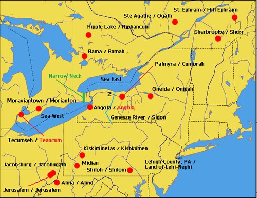
El Libro de Mormón contiene 345 nombres. La teoría, propuesta por Vernal Holley y publicado por Mazeministries, es que 28 de estos nombres fueron derivados por Joseph Smith al ver los nombres de los lugares de la región circundante, a continuación, alterando los nombres ligeramente para crear un mapa de tierras del Libro de Mormón. El mapa original de la que el autor obtuvo esta información incluye los nombres de lugares que ni siquiera existían en la época de José Smith.
- Hecho:
Los siguientes correspondencias se enumeran. Con el fin de obtener esta lista de paralelismos, una enorme zona geográfica debe ser escaneado: Cinco estados y dos provincias canadienses producen esta lista de paralelos y se pone aún más pequeño cuando uno realmente trata de localizar muchos de estos lugares en un mapa. En la siguiente lista,
- Los nombres en rojo indican los lugares que, o bien no contaban con ese nombre hasta después de 1830, o no se puede encontrar en un mapa o en el Libro de Mormón.
- Los nombres en azul indican los nombres que se encuentran en la Biblia.
- Los nombres en verde indican nombres que podrían ser un partido válido.
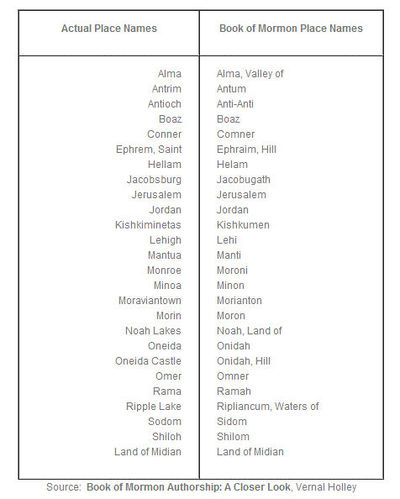
- Nombres lugar real = Libro de Mormón Topónimos
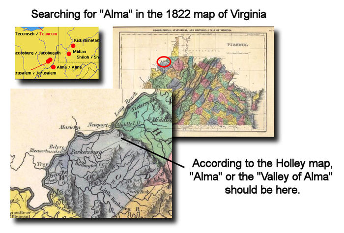
- Alma = Alma, el Valle de—En la zona indicada en el mapa Holley, mapas modernos muestran que existe una pequeña comunidad no incorporada llamada Centerville, también conocido como Alma, en el condado de Tyler, West Virginia, Estados Unidos. coordina: 39°25′55″N 80°50′24″W. Sin embargo, cuando vemos el mapa de 1822 de Virginia, no podemos encontrar el nombre de "Alma" en cualquier lugar.
- Antrim = Antum—"Antrim Township" se encuentra en el condado de Franklin, Pennsylvania. Fue nombrado después del condado de Antrim en Irlanda del Norte. El municipio fue organizado en 1741.
- Antioch = Anti-Anti—The name "Anti-Anti" doesn't even appear in the Book of Mormon, nor does the biblical name "Antioch."
- Boaz = Boaz—The name "Boaz" is from the Bible. Joseph would not have needed to look at a map for this one, unless one accepts Holley's assertion that the Holley map is supposed to show the geographical locations of Book of Mormon places.
- Conner = Comner—The name "Comner" doesn't appear in the Book of Mormon. The name "Comnor" does, in Ether 14:28. Of course, "Comnor" doesn't match "Conner" quite as closely in spelling. We cannot find "Connor" in either New York or Pennsylvania.
- Ephrem, Saint = Ephraim, Hill—The actual name is "Saint-Éphrem-de-Beauce, Quebec." Wikipedia shows the town being established with that name in 1866. This is 36 years after the publication of the Book of Mormon. The Book of Mormon name "Ephraim," of course, is easily found in the Bible.
- Hellam = Helam—According to their website, Hellam Township, Pennsylvania, was established in 1739.
- Jacobsburg = Jacobugath.—Jacobsburg, Belmont Co., Ohio does not even show up on a 1822 map of Ohio.
- Jerusalem = Jerusalem.—Jerusalem, Monroe Co., Ohio does not even show up on a 1822 map of Ohio. Even today the village of Jerusalem occupies only 0.2 square miles. Besides, the name "Jerusalem" is from the Bible. Joseph would not have needed to look at a map for this one, unless one accepts Holley's assertion that the Holley map is supposed to show the geographical locations of Book of Mormon places.
- Jordan = Jordan—The name "Jordan" is from the Bible. Joseph would not have needed to look at a map for this one, unless one accepts Holley's assertion that the Holley map is supposed to show the geographical locations of Book of Mormon places.
- Kishkiminetas = Kishkumen—Kiskiminetas Township, Armstrong County, Pennsylvania was given that name in 1832, two years after the Book of Mormon was published. From History of Armstrong County Pennsylvania, written in 1883 by Robert Walter Smith, "The petition of sundry inhabitants of Allegheny township was presented December 22, 1831, to the court of quarter sessions of this county, asking that a new township be formed out of the upper end of Allegheny township, to be called Kiskiminetas. Philip Klingensmith, John Lafferty and John McKissen were appointed viewers, who, after one continuance of their order, presented their report recommending the organization of the new township, which was approved by the court June 19, 1832." off-site (Inglés) Kiskiminetas River in Pennsylvania does exist prior to the town, and one would assume that it would show up on a map. The Holley map, however, does not indicate that Kishkiminetas is a river, but rather a place.
- Lehigh = Lehi—There is indeed a "Lehigh Valley" located in Pennsylvania.
- Mantua = Manti—According to their website, Mantua Village, Ohio, was incorporated in 1898. This is 68 years after the publication of the Book of Mormon.
- Monroe = Moroni—The author, in the next section, presumes that the name "Moroni" was derived from the capital city of the Comoros Islands, or from "treasure stories" about Captain Kidd. There is a town "Monroe, New York" which was founded in 1818.
- Minoa = Minon—According to the Minoa town website, the town of Minoa, New York received that name in 1895. That is 60 years after the Book of Mormon was published.
- Moraviantown = Morianton—Moravian Indian Reserve No. 47, Ontario, appears to have been established in 1782.
- Morin = Moron—According to Wikipedia, Morin Township, Quebec, was formed in 1852. This would be 22 years after the Book of Mormon was published.
- Noah Lakes = Noah, Land of—The name "Noah" is from the Bible. Joseph would not have needed to look at a map for this one, unless one accepts Holley's assertion that the Holley map is supposed to show the geographical locations of Book of Mormon places.
- Oneida = Onidah—See "Oneida Castle".
- Oneida Castle = Onidah, Hill—Oneida Castle, New York is located at 43°4′42″N 75°38′0″W. The town has existed since the 18th century.
- Omer = Omner—We cannot find "Omer" on any modern map of Pennsylvania, New York or Canada.
- Rama = Ramah—Rama Township, Ontario, was "first surveyed in 1834." [1] This is four years after the publication of the Book of Mormon.
- Ripple Lake = Ripliancum, Waters of.—Ripple Lake is so small that it is difficult to locate on modern day maps, and it is one of more than 250,000 lakes in Ontario. Are we to assume that Joseph selected this one location amongst many, and then converted the name "Ripple Lake" to "Ripliancum?"
- Sodom = Sidom—The name "Sodom," of course, is well known from the Bible. Joseph would not have needed to look at a map for this one, unless one accepts Holley's assertion that the Holley map is supposed to show the geographical locations of Book of Mormon places.
- Shiloh = Shilom—The name "Shiloh" is a biblical name. There is a Shiloh, Pennsylvania on modern maps.
- Land of Midian = Land of Midian—The name "Land of Midian" is from the Bible and it is located in Egypt. Joseph would not have needed to look at a map for this one, unless one accepts Holley's assertion that the Holley map is supposed to show the geographical locations of Book of Mormon places. We are unable to locate a "Midian" or "Land of Midian" on any modern map of Pennsylvania.
- Respuesta:
Not only are the names claimed to be similar to those in the Book of Mormon, but also that the locations of those names are similar. In addition, since some of these names could have easily been taken from the Bible instead of the surrounding region, one must assume that their inclusion on the map also implies that their geographical locations relative to one another are important.
- El autor tiene un dato incorrecto:
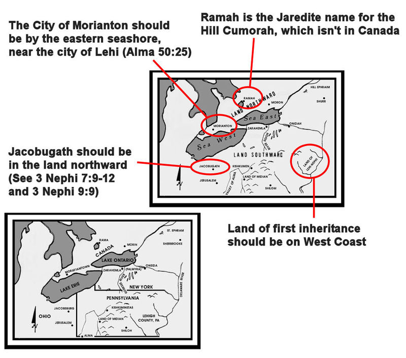
Looking at the geography, it is clear from Holley's map that a number of locations have been selected to make the names match the existing geography. Some examples:
- The map places Jacobugath, site of "King Jacob's" dissenters far in the land southward, when the Book of Mormon has it far in the land northward (3 Nephi 7:9-12; see also 3 Nephi 9:9).
- The map places the land of first inheritance [land of Lehi-Nephi] is on the eastern coast of the United States, while the Book of Mormon is clear that Lehi and his group landed on the western coast.
- The City of Morianton should be by the eastern seashore, near the city of Lehi (Alma 50:25).
- "Ramah" is the Jaredite name for the Hill Cumorah (Ether 15:11). The Hill Cumorah is not in Canada.
Nombres de lugares en América del Norte - El mapa de Vernal Holley
Sumario: Vernal Holley ha reconstruido una geografía del Libro de Mormón en base a un ajuste de los Grandes Lagos en el Libro de Mormón de texto, que luego se compara con la de Nueva Inglaterra de la época de José Smith.
Notas
- [back] Reflections of the Past : the story of Rama Township : a joint project of the Township of Rama and the Orillia Public Library, off-site (Inglés)
